
$250,000
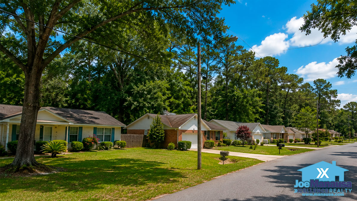
Lakewood Village · Northwest Tallahassee
Lakewood Village Homes for Sale
Last updated: November 12, 2026
Lakewood Village is a neighborhood of 260 single-family homes in Northwest Tallahassee. Homes here were built from 1969 through 2022.
Lakewood Village market intelligence
3
This count comes from our last check of the multiple listing service (MLS).
Lakewood Village Homes for Sale
At a glance
Lakewood Village Key Facts
- Location: Northwest Tallahassee
- ZIP Code: 32303
- Homes: 260 single-family homes
- Construction Era: From 1969 through 2022; median year built 1978
- Median home size: 1,605 square feet
- Most common layout: 3 bedrooms, 2 bathrooms
- Association dues: $25 a year
- Owner-Occupied: 81% owner occupied
- Elementary school: Springwood Elementary, 3.5 miles, Florida DOE school grade B (2026), (850) 488-6225
- Middle school: Griffin Middle, 7.8 miles, Florida DOE school grade C (2026), (850) 617-5353
- High school: Godby High, 7.3 miles, Florida DOE school grade C (2026), (850) 617-4700
- Median lot size: 0.33 acres
Property and Neighborhood Explorer
Lakewood Village Boundary and Lots
The map below outlines the Lakewood Village boundary and every lot inside it. A click on any lot shows its last sale, and the search box finds a home by address.
Zoom in and click any lot for its details.
Loading the Lakewood Village property map…
© Mapbox © OpenStreetMap
Neighborhoods Near Lakewood Village
- Autumn Woods, adjoining, 311 homes
- Shadywood, adjoining, 19 homes
- Rocky Hill, adjoining, 24 homes
- Shaw, 0.0 miles, 13 homes
- Arnold Smith Sub, 0.1 miles, 5 homes
- Stoneler Road Estates, 0.1 miles, 9 homes
- Wildwood, 0.1 miles, 52 homes
- Autumn Estates, 0.3 miles, 48 homes
- Sterling Woods, 0.3 miles, 97 homes
- Sunny Village, 0.4 miles, 29 homes
Every Tallahassee neighborhood we cover is in the neighborhood directory, so you can line Lakewood Village up against any of them.
Available now
Lakewood Village Homes for Sale
3homes for sale
$299,999
$249,000
© 2026 Tallahassee MLS (CATRS). All rights reserved. The data relating to real estate for sale on this web site comes in part from the Internet Data Exchange Program of CATRS. Real estate listings held by IDX Brokerage firms other than Xcellence Realty are marked with the Internet Data Exchange logo or the Internet Data Exchange thumbnail logo and detailed information about them includes the names of the listing brokers. The information being provided is for consumers' personal, non-commercial use and may not be used for any purpose other than to identify prospective properties consumers may be interested in purchasing. Information is deemed reliable but not guaranteed. Data last updated: Friday, November 13th, 2026 at 06:20:05 AM.
Homes and setting
Lakewood Village Homes: 260 Single-Family Homes
All 260 homes in Lakewood Village are single-family homes, built from 1969 through 2022.
The median home size in Lakewood Village is 1,605 square feet of heated and cooled space. The most common layout here is three bedrooms and two bathrooms.
In Lakewood Village, 49% of owners have held their home for ten years or more.
Lakewood Village is mostly owner occupied, with owners living in 81% of the homes.
Lakewood Village is in ZIP code 32303. The homes here line Mossy Top Way, Lunker Lane, Doonesbury Way, Widgeon Way, and Bowfin Drive.
Drive Times From Lakewood Village
Downtown & campus
I-10, Exit 196
about 8 minutes
3.6 miles
Bobby Bowden-Tallahassee International Airport
about 17 minutes
9.3 miles
Florida Capitol
about 19 minutes
10.3 miles
Florida State University
about 19 minutes
9 miles
Florida A&M University
about 23 minutes
10.4 miles
Hospitals
The coast
Hospitals
HCA Florida Capital Hospital
about 18 minutes
12.5 miles
Tallahassee Memorial Hospital
about 20 minutes
10.5 miles
The coast
Shields Marina, St. Marks
about 44 minutes
30.2 miles
Carrabelle Marina
about 1 hour 20 minutes
62.4 miles
St. George Island
about 1 hour 45 minutes
100.5 miles
Association and Dues
Lakewood Village has its own homeowners association. The dues are $25 a year as of 2025. Dues can change from time to time, so confirm the current amount with your Joe Manausa Team member before you make an offer.
Lakewood Village market
Lakewood Village Home Prices and Sales
5Sales closed, past 12 months
260Lakewood Village homes
Sales records for Lakewood Village begin in 1991 and run through November 12, 2026. The figures below leave out family transfers, bank sales, and short sales.
How Much Do Lakewood Village Homes Sell For?
Median price of the homes sold each year in Lakewood Village, existing homes and new construction, with 2026 covering January to November
Medians describe the homes that sold each year, not the value of any one home.
A dot on its own marks a year with sales but no sales the year before or after.
Sources: Tallahassee Board of Realtors Multiple Listing Service and the Leon County Property Appraiser. Sales updated November 12, 2026.
New construction and existing homes are always charted separately, so a year's new-construction figure can come from just one or two sales.
Annual figures
| Year | Lakewood Village existing homes | Lakewood Village new construction | Leon County existing homes | Leon County new construction | Lakewood Village sales (existing / new) |
|---|---|---|---|---|---|
| 2026 | $260,000 | $305,000 | $436,000 | 4 / 0 | |
| 2025 | $262,800 | $356,900 | $289,600 | $419,900 | 9 / 1 |
| 2024 | $255,000 | $288,500 | $416,150 | 9 / 0 | |
| 2023 | $295,000 | $270,000 | $410,700 | 5 / 0 | |
| 2022 | $240,000 | $245,000 | $415,750 | 12 / 0 | |
| 2021 | $205,000 | $225,000 | $325,000 | 13 / 0 | |
| 2020 | $185,000 | $215,000 | $302,150 | 10 / 0 | |
| 2019 | $170,000 | $195,000 | $279,900 | 24 / 0 | |
| 2018 | $164,750 | $188,000 | $310,500 | 12 / 0 | |
| 2017 | $143,500 | $185,000 | $285,400 | 12 / 0 | |
| 2016 | $134,500 | $178,400 | $289,000 | 6 / 0 | |
| 2015 | $111,650 | $178,000 | $269,850 | 4 / 0 | |
| 2014 | $138,000 | $176,000 | $276,100 | 3 / 0 | |
| 2013 | $115,450 | $175,000 | $282,900 | 6 / 0 | |
| 2012 | $125,000 | $169,000 | $270,900 | 1 / 0 | |
| 2011 | $167,800 | $244,650 | 0 / 0 | ||
| 2010 | $147,500 | $170,000 | $192,000 | 6 / 0 | |
| 2009 | $137,650 | $168,000 | $184,500 | 6 / 0 | |
| 2008 | $160,000 | $202,500 | $177,500 | $202,250 | 7 / 2 |
| 2007 | $180,000 | $199,900 | $179,600 | $193,500 | 7 / 1 |
| 2006 | $170,000 | $176,500 | $183,500 | 17 / 0 | |
| 2005 | $154,500 | $166,050 | 16 / 0 | ||
| 2004 | $132,950 | $149,000 | 14 / 0 | ||
| 2003 | $113,900 | $134,900 | 18 / 0 | ||
| 2002 | $123,000 | $122,000 | 8 / 0 | ||
| 2001 | $97,000 | $115,000 | 17 / 0 | ||
| 2000 | $93,450 | $105,000 | 16 / 0 | ||
| 1999 | $90,000 | $102,000 | 19 / 0 | ||
| 1998 | $95,000 | $99,000 | 16 / 0 | ||
| 1997 | $82,400 | $90,000 | 8 / 0 | ||
| 1996 | $88,200 | $90,000 | 12 / 0 | ||
| 1995 | $80,000 | $85,000 | 21 / 0 | ||
| 1994 | $75,000 | $79,000 | 25 / 0 | ||
| 1993 | $75,950 | $77,500 | 22 / 0 | ||
| 1992 | $73,600 | $73,300 | 31 / 0 | ||
| 1991 | $70,000 | $68,500 | 15 / 0 | ||
| 1990 | $67,300 | $68,000 | 28 / 0 | ||
| 1989 | $65,750 | $63,000 | 24 / 0 | ||
| 1988 | $63,700 | $61,850 | 27 / 0 | ||
| 1987 | $64,000 | $61,400 | 21 / 0 | ||
| 1986 | $62,500 | $59,500 | 22 / 0 | ||
| 1985 | $58,900 | $58,900 | 17 / 0 | ||
| 1984 | $61,300 | $55,000 | 14 / 0 | ||
| 1983 | $61,000 | $54,000 | 14 / 0 | ||
| 1982 | $58,450 | $54,500 | 12 / 0 | ||
| 1981 | $58,800 | $51,300 | 17 / 0 | ||
| 1980 | $52,300 | $47,500 | 27 / 0 | ||
| 1979 | $48,000 | $44,500 | 42 / 0 | ||
| 1978 | $44,900 | $40,000 | 27 / 0 | ||
| 1977 | $40,000 | $37,000 | 22 / 0 | ||
| 1976 | $39,000 | $35,500 | 15 / 0 | ||
| 1975 | $39,000 | $36,500 | 13 / 0 | ||
| 1974 | $37,000 | $32,300 | 11 / 0 | ||
| 1973 | $34,200 | $28,500 | 7 / 0 |
How Much Are Lakewood Village Homes Worth?
Median home value, in price per square foot, each year in Lakewood Village, existing homes and new construction, with 2026 covering January to November
Medians describe the homes that sold each year, not the value of any one Lakewood Village home.
A dot on its own marks a year with sales but no sales the year before or after.
Sources: Tallahassee Board of Realtors Multiple Listing Service and the Leon County Property Appraiser. Sales updated November 12, 2026.
New construction and existing homes are always charted separately, so a year's new-construction figure can come from just one or two sales.
Annual figures
| Year | Lakewood Village existing homes | Lakewood Village new construction | Leon County existing homes | Leon County new construction | Lakewood Village sales (existing / new) |
|---|---|---|---|---|---|
| 2026 | $159 | $199 | $236 | 4 / 0 | |
| 2025 | $173 | $199 | $194 | $244 | 9 / 1 |
| 2024 | $156 | $193 | $239 | 9 / 0 | |
| 2023 | $168 | $186 | $231 | 5 / 0 | |
| 2022 | $158 | $170 | $208 | 12 / 0 | |
| 2021 | $128 | $152 | $183 | 13 / 0 | |
| 2020 | $109 | $137 | $173 | 10 / 0 | |
| 2019 | $108 | $126 | $172 | 24 / 0 | |
| 2018 | $106 | $123 | $171 | 12 / 0 | |
| 2017 | $87 | $117 | $164 | 12 / 0 | |
| 2016 | $82 | $113 | $155 | 6 / 0 | |
| 2015 | $68 | $110 | $152 | 4 / 0 | |
| 2014 | $91 | $107 | $147 | 3 / 0 | |
| 2013 | $85 | $105 | $144 | 6 / 0 | |
| 2012 | $78 | $100 | $137 | 1 / 0 | |
| 2011 | $102 | $130 | 0 / 0 | ||
| 2010 | $89 | $109 | $122 | 6 / 0 | |
| 2009 | $77 | $113 | $127 | 6 / 0 | |
| 2008 | $91 | $129 | $122 | $131 | 7 / 2 |
| 2007 | $114 | $128 | $129 | $138 | 7 / 1 |
| 2006 | $112 | $130 | $136 | 17 / 0 | |
| 2005 | 16 / 0 | ||||
| 2004 | 14 / 0 | ||||
| 2003 | 18 / 0 | ||||
| 2002 | 8 / 0 | ||||
| 2001 | 17 / 0 | ||||
| 2000 | 16 / 0 | ||||
| 1999 | 19 / 0 | ||||
| 1998 | 16 / 0 | ||||
| 1997 | 8 / 0 | ||||
| 1996 | 12 / 0 | ||||
| 1995 | 21 / 0 | ||||
| 1994 | 25 / 0 | ||||
| 1993 | 22 / 0 | ||||
| 1992 | 31 / 0 | ||||
| 1991 | 15 / 0 | ||||
| 1990 | 28 / 0 | ||||
| 1989 | 24 / 0 | ||||
| 1988 | 27 / 0 | ||||
| 1987 | 21 / 0 | ||||
| 1986 | 22 / 0 | ||||
| 1985 | 17 / 0 | ||||
| 1984 | 14 / 0 | ||||
| 1983 | 14 / 0 | ||||
| 1982 | 12 / 0 | ||||
| 1981 | 17 / 0 | ||||
| 1980 | 27 / 0 | ||||
| 1979 | 42 / 0 | ||||
| 1978 | 27 / 0 | ||||
| 1977 | 22 / 0 | ||||
| 1976 | 15 / 0 | ||||
| 1975 | 13 / 0 | ||||
| 1974 | 11 / 0 | ||||
| 1973 | 7 / 0 |
How Big Are the Homes That Sell in Lakewood Village?
Median home size, in square feet, each year in Lakewood Village, existing homes and new construction, with 2026 covering January to November
Medians describe the homes that sold each year, not the value of any one home.
A dot on its own marks a year with sales but no sales the year before or after.
Sources: Tallahassee Board of Realtors Multiple Listing Service and the Leon County Property Appraiser. Sales updated November 12, 2026.
New construction and existing homes are always charted separately, so a year's new-construction figure can come from just one or two sales.
Annual figures
| Year | Lakewood Village existing homes | Lakewood Village new construction | Leon County existing homes | Leon County new construction | Lakewood Village sales (existing / new) |
|---|---|---|---|---|---|
| 2026 | 1,644 | 1,569 | 1,873 | 4 / 0 | |
| 2025 | 1,428 | 1,796 | 1,544 | 1,747 | 9 / 1 |
| 2024 | 1,626 | 1,522 | 1,786 | 9 / 0 | |
| 2023 | 1,590 | 1,488 | 1,791 | 5 / 0 | |
| 2022 | 1,540 | 1,476 | 1,935 | 12 / 0 | |
| 2021 | 1,545 | 1,502 | 1,807 | 13 / 0 | |
| 2020 | 1,585 | 1,581 | 1,757 | 10 / 0 | |
| 2019 | 1,526 | 1,569 | 1,670 | 24 / 0 | |
| 2018 | 1,481 | 1,550 | 1,791 | 12 / 0 | |
| 2017 | 1,789 | 1,594 | 1,744 | 12 / 0 | |
| 2016 | 1,694 | 1,626 | 1,803 | 6 / 0 | |
| 2015 | 1,665 | 1,682 | 1,764 | 4 / 0 | |
| 2014 | 1,512 | 1,696 | 1,876 | 3 / 0 | |
| 2013 | 1,545 | 1,700 | 2,010 | 6 / 0 | |
| 2012 | 1,593 | 1,729 | 1,987 | 1 / 0 | |
| 2011 | 1,703 | 1,783 | 0 / 0 | ||
| 2010 | 1,721 | 1,644 | 1,573 | 6 / 0 | |
| 2009 | 1,674 | 1,537 | 1,487 | 6 / 0 | |
| 2008 | 1,658 | 1,568 | 1,504 | 1,570 | 7 / 2 |
| 2007 | 1,498 | 1,566 | 1,465 | 1,535 | 7 / 1 |
| 2006 | 1,549 | 1,469 | 1,470 | 17 / 0 | |
| 2005 | 16 / 0 | ||||
| 2004 | 14 / 0 | ||||
| 2003 | 18 / 0 | ||||
| 2002 | 8 / 0 | ||||
| 2001 | 17 / 0 | ||||
| 2000 | 16 / 0 | ||||
| 1999 | 19 / 0 | ||||
| 1998 | 16 / 0 | ||||
| 1997 | 8 / 0 | ||||
| 1996 | 12 / 0 | ||||
| 1995 | 21 / 0 | ||||
| 1994 | 25 / 0 | ||||
| 1993 | 22 / 0 | ||||
| 1992 | 31 / 0 | ||||
| 1991 | 15 / 0 | ||||
| 1990 | 28 / 0 | ||||
| 1989 | 24 / 0 | ||||
| 1988 | 27 / 0 | ||||
| 1987 | 21 / 0 | ||||
| 1986 | 22 / 0 | ||||
| 1985 | 17 / 0 | ||||
| 1984 | 14 / 0 | ||||
| 1983 | 14 / 0 | ||||
| 1982 | 12 / 0 | ||||
| 1981 | 17 / 0 | ||||
| 1980 | 27 / 0 | ||||
| 1979 | 42 / 0 | ||||
| 1978 | 27 / 0 | ||||
| 1977 | 22 / 0 | ||||
| 1976 | 15 / 0 | ||||
| 1975 | 13 / 0 | ||||
| 1974 | 11 / 0 | ||||
| 1973 | 7 / 0 |
Lakewood Village Recent Sales
| Address | Price | Price / sq ft | Closing date | Year built | Sq ft | Sale type |
|---|---|---|---|---|---|---|
| $255,000 | $148 | 2026-09-30 | 1979 | 1,722 | Existing | |
| $245,000 | $182 | 2026-07-17 | 1983 | 1,344 | Existing | |
| $286,000 | $147 | 2026-07-02 | 1986 | 1,950 | Existing | |
| $265,000 | $169 | 2026-07-02 | 2007 | 1,566 | Existing | |
| $270,000 | $188 | 2025-11-14 | 1983 | 1,440 | Existing | |
| $265,000 | $191 | 2025-10-03 | 2000 | 1,385 | Existing | |
| $285,000 | 2025-09-02 | Existing | ||||
| $230,000 | $205 | 2025-07-30 | 1991 | 1,124 | Existing | |
| $260,000 | $165 | 2025-07-24 | 1981 | 1,574 | Existing | |
| $246,200 | $176 | 2025-05-01 | 1990 | 1,398 | Existing | |
| $262,800 | $113 | 2025-04-30 | 1973 | 2,332 | Existing | |
| $270,000 | $160 | 2025-04-28 | 1973 | 1,683 | Existing | |
| $240,800 | $170 | 2025-04-07 | 1979 | 1,415 | Existing | |
| $356,900 | $199 | 2025-03-21 | 1,796 | New | ||
| $257,500 | $185 | 2024-10-15 | 1983 | 1,392 | Existing | |
| $35,000 | 2024-10-08 | Existing | ||||
| $215,000 | 2024-07-31 | 1980 | Existing | |||
| $280,000 | $163 | 2024-07-16 | 1979 | 1,722 | Existing | |
| $255,000 | $167 | 2024-06-11 | 1973 | 1,529 | Existing | |
| $282,000 | $128 | 2024-03-15 | 1978 | 2,200 | Existing | |
| $227,000 | 2024-03-01 | 1976 | Existing | |||
| $300,000 | $146 | 2024-02-26 | 1974 | 2,050 | Existing | |
| $210,000 | $150 | 2024-02-16 | 1990 | 1,398 | Existing | |
| $215,000 | 2023-12-22 | 1977 | Existing | |||
| $299,000 | $165 | 2023-12-07 | 1979 | 1,814 | Existing | |
| $295,000 | $170 | 2023-08-11 | 1980 | 1,733 | Existing | |
| $300,000 | $207 | 2023-05-02 | 1987 | 1,446 | Existing | |
| $236,000 | $166 | 2023-03-29 | 1973 | 1,419 | Existing | |
| $275,000 | $163 | 2022-12-30 | 1973 | 1,683 | Existing | |
| $230,000 | $165 | 2022-10-20 | 1977 | 1,398 | Existing | |
| $265,000 | $111 | 2022-10-14 | 1969 | 2,392 | Existing | |
| $235,000 | $172 | 2022-06-15 | 1978 | 1,366 | Existing | |
| $245,000 | $141 | 2022-05-20 | 1976 | 1,735 | Existing | |
| $227,500 | $183 | 2022-04-18 | 1988 | 1,244 | Existing | |
| $265,000 | $181 | 2022-04-07 | 1978 | 1,461 | Existing | |
| $245,000 | $187 | 2022-03-22 | 1990 | 1,307 | Existing | |
| $230,000 | $142 | 2022-02-09 | 1973 | 1,615 | Existing | |
| $211,000 | $144 | 2022-02-01 | 1992 | 1,464 | Existing | |
| $230,000 | $126 | 2022-01-20 | 1975 | 1,827 | Existing | |
| $265,000 | $153 | 2022-01-07 | 1980 | 1,733 | Existing | |
| $259,900 | $124 | 2021-08-30 | 1975 | 2,096 | Existing | |
| $190,000 | 2021-08-03 | 1973 | Existing | |||
| $205,000 | $164 | 2021-07-30 | 1984 | 1,247 | Existing | |
| $220,000 | 2021-07-14 | Existing | ||||
| $200,000 | $142 | 2021-06-28 | 1983 | 1,411 | Existing | |
| $215,000 | $115 | 2021-06-18 | 1973 | 1,870 | Existing | |
| $219,900 | $131 | 2021-05-28 | 1973 | 1,683 | Existing | |
| $140,000 | $67 | 2021-05-17 | 1975 | 2,096 | Existing | |
| $196,000 | $128 | 2021-05-11 | 1973 | 1,529 | Existing | |
| $235,000 | $152 | 2021-04-23 | 1994 | 1,545 | Existing | |
| $222,000 | $120 | 2021-04-08 | 1973 | 1,856 | Existing | |
| $197,000 | $141 | 2021-02-16 | 1983 | 1,400 | Existing | |
| $187,000 | $126 | 2021-01-20 | 2007 | 1,486 | Existing | |
| $171,000 | $124 | 2020-12-18 | 1979 | 1,384 | Existing | |
| $175,000 | 2020-12-11 | Existing | ||||
| $195,000 | $84 | 2020-12-01 | 1973 | 2,311 | Existing | |
| $211,000 | $146 | 2020-07-31 | 1977 | 1,450 | Existing | |
| $197,000 | $109 | 2020-07-13 | 1974 | 1,800 | Existing | |
| $205,000 | $132 | 2020-06-16 | 1979 | 1,548 | Existing | |
| $214,900 | $105 | 2020-06-03 | 1974 | 2,050 | Existing | |
| $159,900 | $101 | 2020-03-31 | 1983 | 1,585 | Existing | |
| $168,000 | $105 | 2020-02-26 | 1973 | 1,593 | Existing | |
| $164,900 | $125 | 2020-01-31 | 1983 | 1,320 | Existing | |
| $185,000 | $93 | 2019-12-31 | 1973 | 1,989 | Existing | |
| $169,900 | $107 | 2019-12-24 | 1980 | 1,591 | Existing | |
| $184,000 | $110 | 2019-12-17 | 1979 | 1,672 | Existing | |
| $148,000 | $84 | 2019-11-08 | 1973 | 1,767 | Existing | |
| $190,000 | $137 | 2019-10-28 | 2003 | 1,387 | Existing | |
| $188,100 | $118 | 2019-09-27 | 1979 | 1,596 | Existing | |
| $170,000 | $91 | 2019-09-03 | 1973 | 1,870 | Existing | |
| $215,000 | $106 | 2019-08-29 | 1980 | 2,032 | Existing | |
| $105,000 | $66 | 2019-08-29 | 1980 | 1,591 | Existing | |
| $155,000 | $108 | 2019-08-23 | 1983 | 1,440 | Existing | |
| $155,400 | $137 | 2019-07-09 | 1991 | 1,136 | Existing | |
| $182,000 | $121 | 2019-06-28 | 1977 | 1,498 | Existing | |
| $190,000 | $126 | 2019-06-19 | 1980 | 1,512 | Existing | |
| $200,000 | $80 | 2019-05-22 | 1976 | 2,510 | Existing | |
| $135,000 | $97 | 2019-05-10 | 1980 | 1,386 | Existing | |
| $170,000 | $109 | 2019-05-08 | 1975 | 1,560 | Existing | |
| $152,300 | $107 | 2019-05-03 | 1983 | 1,422 | Existing | |
| $160,000 | $113 | 2019-04-19 | 1983 | 1,411 | Existing | |
| $183,000 | $119 | 2019-04-03 | 1985 | 1,540 | Existing | |
| $189,500 | $90 | 2019-03-26 | 1973 | 2,112 | Existing | |
| $130,000 | $105 | 2019-03-22 | 1988 | 1,244 | Existing | |
| $163,000 | $115 | 2019-03-14 | 1979 | 1,415 | Existing | |
| $163,500 | $117 | 2019-02-07 | 1977 | 1,398 | Existing | |
| $176,000 | $122 | 2019-01-31 | 1987 | 1,446 | Existing | |
| $155,900 | $102 | 2018-11-29 | 1976 | 1,531 | Existing | |
| $145,000 | $101 | 2018-10-16 | 1979 | 1,435 | Existing | |
| $173,000 | $125 | 2018-09-14 | 1983 | 1,380 | Existing | |
| $177,500 | $104 | 2018-08-03 | 1978 | 1,699 | Existing | |
| $175,000 | $101 | 2018-07-30 | 1976 | 1,735 | Existing | |
| $142,000 | $108 | 2018-07-27 | 1983 | 1,310 | Existing | |
| $149,500 | $108 | 2018-04-26 | 1978 | 1,385 | Existing | |
| $174,500 | $115 | 2018-04-16 | 1980 | 1,512 | Existing | |
| $139,900 | $90 | 2018-04-10 | 1973 | 1,546 | Existing | |
| $178,500 | $123 | 2018-03-26 | 1977 | 1,450 | Existing | |
| $175,000 | $104 | 2018-03-15 | 1973 | 1,683 | Existing | |
| $156,500 | $118 | 2018-02-09 | 1986 | 1,322 | Existing | |
| $194,000 | $89 | 2017-12-28 | 1973 | 2,188 | Existing |
Showing 25 of 100 sales
Sources: the Leon County Property Appraiser and the MLS.
Schools
Schools Serving Lakewood Village
2026–27 attendance zones
Assigned Public Schools
All homes in Lakewood Village are zoned for Springwood Elementary School, Griffin Middle School, and Godby High School.
Springwood Elementary School is 3.5 miles from Lakewood Village and has a Florida DOE school grade of B (2026). Its phone number is (850) 488-6225.
Griffin Middle School is 7.8 miles away and has a Florida DOE school grade of C (2026). Its phone number is (850) 617-5353.
Godby High School is 7.3 miles away and has a Florida DOE school grade of C (2026). Its phone number is (850) 617-4700.
Springwood Elementary SchoolFlorida DOE school grade: B (2026)All 260 homes in Lakewood Village
Griffin Middle SchoolFlorida DOE school grade: C (2026)All 260 homes in Lakewood Village
Godby High SchoolFlorida DOE school grade: C (2026)All 260 homes in Lakewood Village
School zones can change from time to time, so check the current assignment for the exact address before you buy.
The Leon County Schools zone lookup shows the assigned schools for any address.
Other Schools Nearby
Charter Schools
These are tuition-free public schools open to students from any Leon County address.
| School | Driving Distance | Phone | Florida DOE school grade |
|---|---|---|---|
| Tallahassee Classical SchoolPK–12 | 14.2 miles | (850) 296-1970 | B (2026) |
| Florida State University SchoolsK–12 | 17.0 miles | (850) 245-3700 | A (2026) |
| School of Arts and Sciences on ThomasvilleK–8 | 10.1 miles | (850) 386-6566 | A (2026) |
| Tallahassee School of Math and ScienceK–8 | 5.3 miles | (850) 681-7827 | B (2026) |
| School of Arts and Sciences at the CentreK–8 | 7.1 miles | (850) 999-8267 | B (2026) |
Private Schools
The state does not grade these schools. They are listed nearest to Lakewood Village first.
Buying in Lakewood Village
Buying a Home in Lakewood Village
On average, seven homes in Lakewood Village come up for sale each year, 3% of the neighborhood, so a buyer who wants to live here has to be ready when one does. Ready means you choose your agent first, build the plan together, and then find the house. Our plan is to negotiate from what the home is worth, not from an inflated asking price. Ask us for the plan before you start looking.
Plan Your Lakewood Village SearchTo see every home for sale that fits your search, in Lakewood Village or nearby, use the Home Finder.
If you plan to buy here, the Tallahassee home buying guide lays out the steps in order.
To turn a Lakewood Village price into a monthly payment, use the mortgage calculator.
Selling in Lakewood Village
Selling a Home in Lakewood Village
Most sellers negotiate with one buyer at a time. Our selling plan is built to bring several buyers together so they compete for your home. Ask us how that plan would work when you sell in Lakewood Village.
If you own a home here and plan to sell, the Tallahassee home selling guide covers what to decide before the home goes on the market.
To learn what your Lakewood Village home is worth today, request a home evaluation.
The home marketing plan shows how our selling plan is built to bring several buyers to the same home.
Flood zones by address
The lots for 114 of the 260 homes touch or overlap a high-risk flood zone.
- High flood risk (A)
- FEMA's map does not give an expected flood level for this zone.
- Outside high-risk zones (unshaded X)
- FEMA places this zone outside its high-risk flood area. Small streams and local drainage problems can still cause flooding.
Addresses with lots that touch or overlap a high-risk flood zone
- 5005 STONELER RD
- 5525 MOSSY TOP WAY
- 4345 SNOOPY LN
- 4341 SNOOPY LN
- 4337 SNOOPY LN
- 4333 SNOOPY LN
- 4329 SNOOPY LN
- 4325 SNOOPY LN
- 4321 SNOOPY LN
- 4317 SNOOPY LN
- 4313 SNOOPY LN
- 4309 SNOOPY LN
- 4305 SNOOPY LN
- 4296 SNOOPY LN
- 4304 SNOOPY LN
- 4308 SNOOPY LN
- 4312 SNOOPY LN
- 4318 SNOOPY LN
- 4324 SNOOPY LN
- 4330 SNOOPY LN
- 4338 SNOOPY LN
- 4342 SNOOPY LN
- 5535 MOSSY TOP WAY
- 5539 MOSSY TOP WAY
- 5543 MOSSY TOP WAY
- 5547 MOSSY TOP WAY
- 5605 MOSSY TOP WAY
- 5609 MOSSY TOP WAY
- 5613 MOSSY TOP WAY
- 5617 MOSSY TOP WAY
- 5625 MOSSY TOP WAY
- 5629 MOSSY TOP WAY
- 5633 MOSSY TOP WAY
- 4301 MOSSY TOP CT
- 4307 MOSSY TOP CT
- 4309 MOSSY TOP CT
- 4308 MOSSY TOP CT
- 4304 MOSSY TOP CT
- 4300 MOSSY TOP CT
- 4317 CALCUTTA CT
- 4313 CALCUTTA CT
- 4309 CALCUTTA CT
- 4305 CALCUTTA CT
- 4301 CALCUTTA CT
- 4300 CALCUTTA CT
- 4400 BLUE BILL PASS
- 4404 BLUE BILL PASS
- 4408 BLUE BILL PASS
- 4412 BLUE BILL PASS
- 4416 BLUE BILL PASS
- 4420 BLUE BILL PASS
- 4424 BLUE BILL PASS
- 4428 BLUE BILL PASS
- 4432 BLUE BILL PASS
- 4436 BLUE BILL PASS
- 4440 BLUE BILL PASS
- 4505 ZONKER CT
- 4509 ZONKER CT
- 4513 ZONKER CT
- 4517 ZONKER CT
- 4520 ZONKER CT
- 4516 ZONKER CT
- 4512 ZONKER CT
- 4508 ZONKER CT
- 4504 ZONKER CT
- 5821 DOONESBURY CT
- 5825 DOONESBURY CT
- 5829 DOONESBURY CT
- 5832 DOONESBURY CT
- 5828 DOONESBURY CT
- 5824 DOONESBURY CT
- 5820 DOONESBURY CT
- 5812 DOONESBURY WAY
- 5808 DOONESBURY WAY
- 5800 DOONESBURY WAY
- 4423 BLUE BILL PASS
- 4415 BLUE BILL PASS
- 4407 BLUE BILL PASS
- 4308 CALCUTTA CT
- 5606 MOSSY TOP WAY
- 5605 LUNKER LN
- 5611 LUNKER LN
- 5648 MOSSY TOP WAY
- 5644 MOSSY TOP WAY
- 5632 MOSSY TOP WAY
- 5628 MOSSY TOP WAY
- 5624 MOSSY TOP WAY
- 5620 MOSSY TOP WAY
- 5616 MOSSY TOP WAY
- 5612 MOSSY TOP WAY
- 5608 MOSSY TOP WAY
- 5512 MOSSY TOP WAY
- 5516 MOSSY TOP WAY
- 5520 MOSSY TOP WAY
- 5532 MOSSY TOP WAY
- 5536 MOSSY TOP WAY
- 5540 MOSSY TOP WAY
- 5612 LUNKER LN
- 5616 LUNKER LN
- 5620 LUNKER LN
- 5525 BLACK BASS PASS
- 5521 BLACK BASS PASS
- 5517 BLACK BASS PASS
- 5513 BLACK BASS PASS
- 5748 DOONESBURY WAY
- 5744 DOONESBURY WAY
- 5740 DOONESBURY WAY
- 5736 DOONESBURY WAY
- 5732 DOONESBURY WAY
- 5726 DOONESBURY WAY
- 5718 DOONESBURY WAY
- 5710 DOONESBURY WAY
- 5704 DOONESBURY WAY
- 5700 DOONESBURY WAY
| Address | Flood zone What the zone means |
|---|---|
| 5005 STONELER RD | High flood risk (A): FEMA's map does not give an expected flood level for this zone.; Outside high-risk zones (unshaded X): FEMA places this zone outside its high-risk flood area. Small streams and local drainage problems can still cause flooding. |
| 5009 STONELER RD | Outside high-risk zones (unshaded X): FEMA places this zone outside its high-risk flood area. Small streams and local drainage problems can still cause flooding. |
| 5013 STONELER RD | Outside high-risk zones (unshaded X): FEMA places this zone outside its high-risk flood area. Small streams and local drainage problems can still cause flooding. |
| 5017 STONELER RD | Outside high-risk zones (unshaded X): FEMA places this zone outside its high-risk flood area. Small streams and local drainage problems can still cause flooding. |
| 5021 STONELER RD | Outside high-risk zones (unshaded X): FEMA places this zone outside its high-risk flood area. Small streams and local drainage problems can still cause flooding. |
| 5025 STONELER RD | Outside high-risk zones (unshaded X): FEMA places this zone outside its high-risk flood area. Small streams and local drainage problems can still cause flooding. |
| 5029 STONELER RD | Outside high-risk zones (unshaded X): FEMA places this zone outside its high-risk flood area. Small streams and local drainage problems can still cause flooding. |
| 5105 VILLAGE WAY | Outside high-risk zones (unshaded X): FEMA places this zone outside its high-risk flood area. Small streams and local drainage problems can still cause flooding. |
| 4553 BOWFIN DR | Outside high-risk zones (unshaded X): FEMA places this zone outside its high-risk flood area. Small streams and local drainage problems can still cause flooding. |
| 4549 BOWFIN DR | Outside high-risk zones (unshaded X): FEMA places this zone outside its high-risk flood area. Small streams and local drainage problems can still cause flooding. |
| 4545 BOWFIN DR | Outside high-risk zones (unshaded X): FEMA places this zone outside its high-risk flood area. Small streams and local drainage problems can still cause flooding. |
| 4541 BOWFIN DR | Outside high-risk zones (unshaded X): FEMA places this zone outside its high-risk flood area. Small streams and local drainage problems can still cause flooding. |
| 4537 BOWFIN DR | Outside high-risk zones (unshaded X): FEMA places this zone outside its high-risk flood area. Small streams and local drainage problems can still cause flooding. |
| 4533 BOWFIN DR | Outside high-risk zones (unshaded X): FEMA places this zone outside its high-risk flood area. Small streams and local drainage problems can still cause flooding. |
| 4529 BOWFIN DR | Outside high-risk zones (unshaded X): FEMA places this zone outside its high-risk flood area. Small streams and local drainage problems can still cause flooding. |
| 4525 BOWFIN DR | Outside high-risk zones (unshaded X): FEMA places this zone outside its high-risk flood area. Small streams and local drainage problems can still cause flooding. |
| 4521 BOWFIN DR | Outside high-risk zones (unshaded X): FEMA places this zone outside its high-risk flood area. Small streams and local drainage problems can still cause flooding. |
| 4517 BOWFIN DR | Outside high-risk zones (unshaded X): FEMA places this zone outside its high-risk flood area. Small streams and local drainage problems can still cause flooding. |
| 4513 BOWFIN DR | Outside high-risk zones (unshaded X): FEMA places this zone outside its high-risk flood area. Small streams and local drainage problems can still cause flooding. |
| 4509 BOWFIN DR | Outside high-risk zones (unshaded X): FEMA places this zone outside its high-risk flood area. Small streams and local drainage problems can still cause flooding. |
| 4505 BOWFIN DR | Outside high-risk zones (unshaded X): FEMA places this zone outside its high-risk flood area. Small streams and local drainage problems can still cause flooding. |
| 4501 BOWFIN DR | Outside high-risk zones (unshaded X): FEMA places this zone outside its high-risk flood area. Small streams and local drainage problems can still cause flooding. |
| 4413 WIDGEON WAY | Outside high-risk zones (unshaded X): FEMA places this zone outside its high-risk flood area. Small streams and local drainage problems can still cause flooding. |
| 4409 WIDGEON WAY | Outside high-risk zones (unshaded X): FEMA places this zone outside its high-risk flood area. Small streams and local drainage problems can still cause flooding. |
| 4405 WIDGEON WAY | Outside high-risk zones (unshaded X): FEMA places this zone outside its high-risk flood area. Small streams and local drainage problems can still cause flooding. |
| 5016 STONELER RD | Outside high-risk zones (unshaded X): FEMA places this zone outside its high-risk flood area. Small streams and local drainage problems can still cause flooding. |
| 5012 STONELER RD | Outside high-risk zones (unshaded X): FEMA places this zone outside its high-risk flood area. Small streams and local drainage problems can still cause flooding. |
| 5008 STONELER RD | Outside high-risk zones (unshaded X): FEMA places this zone outside its high-risk flood area. Small streams and local drainage problems can still cause flooding. |
| 5004 STONELER RD | Outside high-risk zones (unshaded X): FEMA places this zone outside its high-risk flood area. Small streams and local drainage problems can still cause flooding. |
| 5000 STONELER RD | Outside high-risk zones (unshaded X): FEMA places this zone outside its high-risk flood area. Small streams and local drainage problems can still cause flooding. |
| 4552 BOWFIN DR | Outside high-risk zones (unshaded X): FEMA places this zone outside its high-risk flood area. Small streams and local drainage problems can still cause flooding. |
| 4453 WIDGEON WAY | Outside high-risk zones (unshaded X): FEMA places this zone outside its high-risk flood area. Small streams and local drainage problems can still cause flooding. |
| 4548 BOWFIN DR | Outside high-risk zones (unshaded X): FEMA places this zone outside its high-risk flood area. Small streams and local drainage problems can still cause flooding. |
| 4544 BOWFIN DR | Outside high-risk zones (unshaded X): FEMA places this zone outside its high-risk flood area. Small streams and local drainage problems can still cause flooding. |
| 4540 BOWFIN DR | Outside high-risk zones (unshaded X): FEMA places this zone outside its high-risk flood area. Small streams and local drainage problems can still cause flooding. |
| 4536 BOWFIN DR | Outside high-risk zones (unshaded X): FEMA places this zone outside its high-risk flood area. Small streams and local drainage problems can still cause flooding. |
| 4532 BOWFIN DR | Outside high-risk zones (unshaded X): FEMA places this zone outside its high-risk flood area. Small streams and local drainage problems can still cause flooding. |
| 4528 BOWFIN DR | Outside high-risk zones (unshaded X): FEMA places this zone outside its high-risk flood area. Small streams and local drainage problems can still cause flooding. |
| 4512 BOWFIN DR | Outside high-risk zones (unshaded X): FEMA places this zone outside its high-risk flood area. Small streams and local drainage problems can still cause flooding. |
| 4500 BOWFIN DR | Outside high-risk zones (unshaded X): FEMA places this zone outside its high-risk flood area. Small streams and local drainage problems can still cause flooding. |
| 4425 WIDGEON WAY | Outside high-risk zones (unshaded X): FEMA places this zone outside its high-risk flood area. Small streams and local drainage problems can still cause flooding. |
| 4429 WIDGEON WAY | Outside high-risk zones (unshaded X): FEMA places this zone outside its high-risk flood area. Small streams and local drainage problems can still cause flooding. |
| 4433 WIDGEON WAY | Outside high-risk zones (unshaded X): FEMA places this zone outside its high-risk flood area. Small streams and local drainage problems can still cause flooding. |
| 4437 WIDGEON WAY | Outside high-risk zones (unshaded X): FEMA places this zone outside its high-risk flood area. Small streams and local drainage problems can still cause flooding. |
| 4441 WIDGEON WAY | Outside high-risk zones (unshaded X): FEMA places this zone outside its high-risk flood area. Small streams and local drainage problems can still cause flooding. |
| 4445 WIDGEON WAY | Outside high-risk zones (unshaded X): FEMA places this zone outside its high-risk flood area. Small streams and local drainage problems can still cause flooding. |
| 5205 VILLAGE WAY | Outside high-risk zones (unshaded X): FEMA places this zone outside its high-risk flood area. Small streams and local drainage problems can still cause flooding. |
| 5501 MOSSY TOP WAY | Outside high-risk zones (unshaded X): FEMA places this zone outside its high-risk flood area. Small streams and local drainage problems can still cause flooding. |
| 5505 MOSSY TOP WAY | Outside high-risk zones (unshaded X): FEMA places this zone outside its high-risk flood area. Small streams and local drainage problems can still cause flooding. |
| 5509 MOSSY TOP WAY | Outside high-risk zones (unshaded X): FEMA places this zone outside its high-risk flood area. Small streams and local drainage problems can still cause flooding. |
| 5513 MOSSY TOP WAY | Outside high-risk zones (unshaded X): FEMA places this zone outside its high-risk flood area. Small streams and local drainage problems can still cause flooding. |
| 5517 MOSSY TOP WAY | Outside high-risk zones (unshaded X): FEMA places this zone outside its high-risk flood area. Small streams and local drainage problems can still cause flooding. |
| 5521 MOSSY TOP WAY | Outside high-risk zones (unshaded X): FEMA places this zone outside its high-risk flood area. Small streams and local drainage problems can still cause flooding. |
| 5525 MOSSY TOP WAY | High flood risk (A): FEMA's map does not give an expected flood level for this zone.; Outside high-risk zones (unshaded X): FEMA places this zone outside its high-risk flood area. Small streams and local drainage problems can still cause flooding. |
| 4345 SNOOPY LN | High flood risk (A): FEMA's map does not give an expected flood level for this zone.; Outside high-risk zones (unshaded X): FEMA places this zone outside its high-risk flood area. Small streams and local drainage problems can still cause flooding. |
| 4341 SNOOPY LN | High flood risk (A): FEMA's map does not give an expected flood level for this zone.; Outside high-risk zones (unshaded X): FEMA places this zone outside its high-risk flood area. Small streams and local drainage problems can still cause flooding. |
| 4337 SNOOPY LN | High flood risk (A): FEMA's map does not give an expected flood level for this zone.; Outside high-risk zones (unshaded X): FEMA places this zone outside its high-risk flood area. Small streams and local drainage problems can still cause flooding. |
| 4333 SNOOPY LN | High flood risk (A): FEMA's map does not give an expected flood level for this zone.; Outside high-risk zones (unshaded X): FEMA places this zone outside its high-risk flood area. Small streams and local drainage problems can still cause flooding. |
| 4329 SNOOPY LN | High flood risk (A): FEMA's map does not give an expected flood level for this zone.; Outside high-risk zones (unshaded X): FEMA places this zone outside its high-risk flood area. Small streams and local drainage problems can still cause flooding. |
| 4325 SNOOPY LN | High flood risk (A): FEMA's map does not give an expected flood level for this zone.; Outside high-risk zones (unshaded X): FEMA places this zone outside its high-risk flood area. Small streams and local drainage problems can still cause flooding. |
| 4321 SNOOPY LN | High flood risk (A): FEMA's map does not give an expected flood level for this zone.; Outside high-risk zones (unshaded X): FEMA places this zone outside its high-risk flood area. Small streams and local drainage problems can still cause flooding. |
| 4317 SNOOPY LN | High flood risk (A): FEMA's map does not give an expected flood level for this zone.; Outside high-risk zones (unshaded X): FEMA places this zone outside its high-risk flood area. Small streams and local drainage problems can still cause flooding. |
| 4313 SNOOPY LN | High flood risk (A): FEMA's map does not give an expected flood level for this zone.; Outside high-risk zones (unshaded X): FEMA places this zone outside its high-risk flood area. Small streams and local drainage problems can still cause flooding. |
| 4309 SNOOPY LN | High flood risk (A): FEMA's map does not give an expected flood level for this zone.; Outside high-risk zones (unshaded X): FEMA places this zone outside its high-risk flood area. Small streams and local drainage problems can still cause flooding. |
| 4305 SNOOPY LN | High flood risk (A): FEMA's map does not give an expected flood level for this zone.; Outside high-risk zones (unshaded X): FEMA places this zone outside its high-risk flood area. Small streams and local drainage problems can still cause flooding. |
| 5108 STONELER RD | Outside high-risk zones (unshaded X): FEMA places this zone outside its high-risk flood area. Small streams and local drainage problems can still cause flooding. |
| 4400 WIDGEON WAY | Outside high-risk zones (unshaded X): FEMA places this zone outside its high-risk flood area. Small streams and local drainage problems can still cause flooding. |
| 4404 WIDGEON WAY | Outside high-risk zones (unshaded X): FEMA places this zone outside its high-risk flood area. Small streams and local drainage problems can still cause flooding. |
| 4408 WIDGEON WAY | Outside high-risk zones (unshaded X): FEMA places this zone outside its high-risk flood area. Small streams and local drainage problems can still cause flooding. |
| 4412 WIDGEON WAY | Outside high-risk zones (unshaded X): FEMA places this zone outside its high-risk flood area. Small streams and local drainage problems can still cause flooding. |
| 4416 WIDGEON WAY | Outside high-risk zones (unshaded X): FEMA places this zone outside its high-risk flood area. Small streams and local drainage problems can still cause flooding. |
| 4420 WIDGEON WAY | Outside high-risk zones (unshaded X): FEMA places this zone outside its high-risk flood area. Small streams and local drainage problems can still cause flooding. |
| 4424 WIDGEON WAY | Outside high-risk zones (unshaded X): FEMA places this zone outside its high-risk flood area. Small streams and local drainage problems can still cause flooding. |
| 4428 WIDGEON WAY | Outside high-risk zones (unshaded X): FEMA places this zone outside its high-risk flood area. Small streams and local drainage problems can still cause flooding. |
| 4432 WIDGEON WAY | Outside high-risk zones (unshaded X): FEMA places this zone outside its high-risk flood area. Small streams and local drainage problems can still cause flooding. |
| 4436 WIDGEON WAY | Outside high-risk zones (unshaded X): FEMA places this zone outside its high-risk flood area. Small streams and local drainage problems can still cause flooding. |
| 4440 WIDGEON WAY | Outside high-risk zones (unshaded X): FEMA places this zone outside its high-risk flood area. Small streams and local drainage problems can still cause flooding. |
| 4444 WIDGEON WAY | Outside high-risk zones (unshaded X): FEMA places this zone outside its high-risk flood area. Small streams and local drainage problems can still cause flooding. |
| 4448 WIDGEON WAY | Outside high-risk zones (unshaded X): FEMA places this zone outside its high-risk flood area. Small streams and local drainage problems can still cause flooding. |
| 4452 WIDGEON WAY | Outside high-risk zones (unshaded X): FEMA places this zone outside its high-risk flood area. Small streams and local drainage problems can still cause flooding. |
| 4460 WIDGEON WAY | Outside high-risk zones (unshaded X): FEMA places this zone outside its high-risk flood area. Small streams and local drainage problems can still cause flooding. |
| 4464 WIDGEON WAY | Outside high-risk zones (unshaded X): FEMA places this zone outside its high-risk flood area. Small streams and local drainage problems can still cause flooding. |
| 5201 VILLAGE WAY | Outside high-risk zones (unshaded X): FEMA places this zone outside its high-risk flood area. Small streams and local drainage problems can still cause flooding. |
| 4296 SNOOPY LN | High flood risk (A): FEMA's map does not give an expected flood level for this zone. |
| 4304 SNOOPY LN | High flood risk (A): FEMA's map does not give an expected flood level for this zone. |
| 4308 SNOOPY LN | High flood risk (A): FEMA's map does not give an expected flood level for this zone. |
| 4312 SNOOPY LN | High flood risk (A): FEMA's map does not give an expected flood level for this zone. |
| 4318 SNOOPY LN | High flood risk (A): FEMA's map does not give an expected flood level for this zone. |
| 4324 SNOOPY LN | High flood risk (A): FEMA's map does not give an expected flood level for this zone. |
| 4330 SNOOPY LN | High flood risk (A): FEMA's map does not give an expected flood level for this zone. |
| 4338 SNOOPY LN | High flood risk (A): FEMA's map does not give an expected flood level for this zone. |
| 4342 SNOOPY LN | High flood risk (A): FEMA's map does not give an expected flood level for this zone. |
| 5535 MOSSY TOP WAY | High flood risk (A): FEMA's map does not give an expected flood level for this zone. |
| 5539 MOSSY TOP WAY | High flood risk (A): FEMA's map does not give an expected flood level for this zone. |
| 5543 MOSSY TOP WAY | High flood risk (A): FEMA's map does not give an expected flood level for this zone. |
| 5547 MOSSY TOP WAY | High flood risk (A): FEMA's map does not give an expected flood level for this zone. |
| 5605 MOSSY TOP WAY | High flood risk (A): FEMA's map does not give an expected flood level for this zone. |
| 5609 MOSSY TOP WAY | High flood risk (A): FEMA's map does not give an expected flood level for this zone. |
| 5613 MOSSY TOP WAY | High flood risk (A): FEMA's map does not give an expected flood level for this zone. |
| 5617 MOSSY TOP WAY | High flood risk (A): FEMA's map does not give an expected flood level for this zone. |
| 5625 MOSSY TOP WAY | High flood risk (A): FEMA's map does not give an expected flood level for this zone. |
| 5629 MOSSY TOP WAY | High flood risk (A): FEMA's map does not give an expected flood level for this zone. |
| 5633 MOSSY TOP WAY | High flood risk (A): FEMA's map does not give an expected flood level for this zone. |
| 4301 MOSSY TOP CT | High flood risk (A): FEMA's map does not give an expected flood level for this zone. |
| 4307 MOSSY TOP CT | High flood risk (A): FEMA's map does not give an expected flood level for this zone. |
| 4309 MOSSY TOP CT | High flood risk (A): FEMA's map does not give an expected flood level for this zone. |
| 4308 MOSSY TOP CT | High flood risk (A): FEMA's map does not give an expected flood level for this zone. |
| 4304 MOSSY TOP CT | High flood risk (A): FEMA's map does not give an expected flood level for this zone. |
| 4300 MOSSY TOP CT | High flood risk (A): FEMA's map does not give an expected flood level for this zone. |
| 4317 CALCUTTA CT | High flood risk (A): FEMA's map does not give an expected flood level for this zone.; Outside high-risk zones (unshaded X): FEMA places this zone outside its high-risk flood area. Small streams and local drainage problems can still cause flooding. |
| 4313 CALCUTTA CT | High flood risk (A): FEMA's map does not give an expected flood level for this zone.; Outside high-risk zones (unshaded X): FEMA places this zone outside its high-risk flood area. Small streams and local drainage problems can still cause flooding. |
| 4309 CALCUTTA CT | High flood risk (A): FEMA's map does not give an expected flood level for this zone. |
| 4305 CALCUTTA CT | High flood risk (A): FEMA's map does not give an expected flood level for this zone. |
| 4301 CALCUTTA CT | High flood risk (A): FEMA's map does not give an expected flood level for this zone. |
| 4300 CALCUTTA CT | High flood risk (A): FEMA's map does not give an expected flood level for this zone. |
| 4400 BLUE BILL PASS | High flood risk (A): FEMA's map does not give an expected flood level for this zone. |
| 4404 BLUE BILL PASS | High flood risk (A): FEMA's map does not give an expected flood level for this zone. |
| 4408 BLUE BILL PASS | High flood risk (A): FEMA's map does not give an expected flood level for this zone. |
| 4412 BLUE BILL PASS | High flood risk (A): FEMA's map does not give an expected flood level for this zone. |
| 4416 BLUE BILL PASS | High flood risk (A): FEMA's map does not give an expected flood level for this zone. |
| 4420 BLUE BILL PASS | High flood risk (A): FEMA's map does not give an expected flood level for this zone. |
| 4424 BLUE BILL PASS | High flood risk (A): FEMA's map does not give an expected flood level for this zone. |
| 4428 BLUE BILL PASS | High flood risk (A): FEMA's map does not give an expected flood level for this zone. |
| 4432 BLUE BILL PASS | High flood risk (A): FEMA's map does not give an expected flood level for this zone.; Outside high-risk zones (unshaded X): FEMA places this zone outside its high-risk flood area. Small streams and local drainage problems can still cause flooding. |
| 4436 BLUE BILL PASS | High flood risk (A): FEMA's map does not give an expected flood level for this zone.; Outside high-risk zones (unshaded X): FEMA places this zone outside its high-risk flood area. Small streams and local drainage problems can still cause flooding. |
| 4440 BLUE BILL PASS | High flood risk (A): FEMA's map does not give an expected flood level for this zone.; Outside high-risk zones (unshaded X): FEMA places this zone outside its high-risk flood area. Small streams and local drainage problems can still cause flooding. |
| 4444 BLUE BILL PASS | Outside high-risk zones (unshaded X): FEMA places this zone outside its high-risk flood area. Small streams and local drainage problems can still cause flooding. |
| 4448 BLUE BILL PASS | Outside high-risk zones (unshaded X): FEMA places this zone outside its high-risk flood area. Small streams and local drainage problems can still cause flooding. |
| 4501 ZONKER CT | Outside high-risk zones (unshaded X): FEMA places this zone outside its high-risk flood area. Small streams and local drainage problems can still cause flooding. |
| 4505 ZONKER CT | High flood risk (A): FEMA's map does not give an expected flood level for this zone.; Outside high-risk zones (unshaded X): FEMA places this zone outside its high-risk flood area. Small streams and local drainage problems can still cause flooding. |
| 4509 ZONKER CT | High flood risk (A): FEMA's map does not give an expected flood level for this zone.; Outside high-risk zones (unshaded X): FEMA places this zone outside its high-risk flood area. Small streams and local drainage problems can still cause flooding. |
| 4513 ZONKER CT | High flood risk (A): FEMA's map does not give an expected flood level for this zone. |
| 4517 ZONKER CT | High flood risk (A): FEMA's map does not give an expected flood level for this zone. |
| 4520 ZONKER CT | High flood risk (A): FEMA's map does not give an expected flood level for this zone. |
| 4516 ZONKER CT | High flood risk (A): FEMA's map does not give an expected flood level for this zone. |
| 4512 ZONKER CT | High flood risk (A): FEMA's map does not give an expected flood level for this zone. |
| 4508 ZONKER CT | High flood risk (A): FEMA's map does not give an expected flood level for this zone. |
| 4504 ZONKER CT | High flood risk (A): FEMA's map does not give an expected flood level for this zone. |
| 5821 DOONESBURY CT | High flood risk (A): FEMA's map does not give an expected flood level for this zone.; Outside high-risk zones (unshaded X): FEMA places this zone outside its high-risk flood area. Small streams and local drainage problems can still cause flooding. |
| 5825 DOONESBURY CT | High flood risk (A): FEMA's map does not give an expected flood level for this zone. |
| 5829 DOONESBURY CT | High flood risk (A): FEMA's map does not give an expected flood level for this zone. |
| 5832 DOONESBURY CT | High flood risk (A): FEMA's map does not give an expected flood level for this zone. |
| 5828 DOONESBURY CT | High flood risk (A): FEMA's map does not give an expected flood level for this zone. |
| 5824 DOONESBURY CT | High flood risk (A): FEMA's map does not give an expected flood level for this zone. |
| 5820 DOONESBURY CT | High flood risk (A): FEMA's map does not give an expected flood level for this zone.; Outside high-risk zones (unshaded X): FEMA places this zone outside its high-risk flood area. Small streams and local drainage problems can still cause flooding. |
| 5812 DOONESBURY WAY | High flood risk (A): FEMA's map does not give an expected flood level for this zone.; Outside high-risk zones (unshaded X): FEMA places this zone outside its high-risk flood area. Small streams and local drainage problems can still cause flooding. |
| 5808 DOONESBURY WAY | High flood risk (A): FEMA's map does not give an expected flood level for this zone.; Outside high-risk zones (unshaded X): FEMA places this zone outside its high-risk flood area. Small streams and local drainage problems can still cause flooding. |
| 5804 DOONESBURY WAY | Outside high-risk zones (unshaded X): FEMA places this zone outside its high-risk flood area. Small streams and local drainage problems can still cause flooding. |
| 5800 DOONESBURY WAY | High flood risk (A): FEMA's map does not give an expected flood level for this zone.; Outside high-risk zones (unshaded X): FEMA places this zone outside its high-risk flood area. Small streams and local drainage problems can still cause flooding. |
| 5701 MOSSY TOP WAY | Outside high-risk zones (unshaded X): FEMA places this zone outside its high-risk flood area. Small streams and local drainage problems can still cause flooding. |
| 5705 MOSSY TOP WAY | Outside high-risk zones (unshaded X): FEMA places this zone outside its high-risk flood area. Small streams and local drainage problems can still cause flooding. |
| 5713 MOSSY TOP WAY | Outside high-risk zones (unshaded X): FEMA places this zone outside its high-risk flood area. Small streams and local drainage problems can still cause flooding. |
| 5717 MOSSY TOP WAY | Outside high-risk zones (unshaded X): FEMA places this zone outside its high-risk flood area. Small streams and local drainage problems can still cause flooding. |
| 5721 MOSSY TOP WAY | Outside high-risk zones (unshaded X): FEMA places this zone outside its high-risk flood area. Small streams and local drainage problems can still cause flooding. |
| 5723 MOSSY TOP WAY | Outside high-risk zones (unshaded X): FEMA places this zone outside its high-risk flood area. Small streams and local drainage problems can still cause flooding. |
| 5725 MOSSY TOP WAY | Outside high-risk zones (unshaded X): FEMA places this zone outside its high-risk flood area. Small streams and local drainage problems can still cause flooding. |
| 4449 BLUE BILL PASS | Outside high-risk zones (unshaded X): FEMA places this zone outside its high-risk flood area. Small streams and local drainage problems can still cause flooding. |
| 4445 BLUE BILL PASS | Outside high-risk zones (unshaded X): FEMA places this zone outside its high-risk flood area. Small streams and local drainage problems can still cause flooding. |
| 4441 BLUE BILL PASS | Outside high-risk zones (unshaded X): FEMA places this zone outside its high-risk flood area. Small streams and local drainage problems can still cause flooding. |
| 4437 BLUE BILL PASS | Outside high-risk zones (unshaded X): FEMA places this zone outside its high-risk flood area. Small streams and local drainage problems can still cause flooding. |
| 4433 BLUE BILL PASS | Outside high-risk zones (unshaded X): FEMA places this zone outside its high-risk flood area. Small streams and local drainage problems can still cause flooding. |
| 4429 BLUE BILL PASS | Outside high-risk zones (unshaded X): FEMA places this zone outside its high-risk flood area. Small streams and local drainage problems can still cause flooding. |
| 4423 BLUE BILL PASS | High flood risk (A): FEMA's map does not give an expected flood level for this zone.; Outside high-risk zones (unshaded X): FEMA places this zone outside its high-risk flood area. Small streams and local drainage problems can still cause flooding. |
| 4415 BLUE BILL PASS | High flood risk (A): FEMA's map does not give an expected flood level for this zone.; Outside high-risk zones (unshaded X): FEMA places this zone outside its high-risk flood area. Small streams and local drainage problems can still cause flooding. |
| 4407 BLUE BILL PASS | High flood risk (A): FEMA's map does not give an expected flood level for this zone.; Outside high-risk zones (unshaded X): FEMA places this zone outside its high-risk flood area. Small streams and local drainage problems can still cause flooding. |
| 4308 CALCUTTA CT | High flood risk (A): FEMA's map does not give an expected flood level for this zone.; Outside high-risk zones (unshaded X): FEMA places this zone outside its high-risk flood area. Small streams and local drainage problems can still cause flooding. |
| 5606 MOSSY TOP WAY | High flood risk (A): FEMA's map does not give an expected flood level for this zone. |
| 5605 LUNKER LN | High flood risk (A): FEMA's map does not give an expected flood level for this zone.; Outside high-risk zones (unshaded X): FEMA places this zone outside its high-risk flood area. Small streams and local drainage problems can still cause flooding. |
| 5611 LUNKER LN | High flood risk (A): FEMA's map does not give an expected flood level for this zone.; Outside high-risk zones (unshaded X): FEMA places this zone outside its high-risk flood area. Small streams and local drainage problems can still cause flooding. |
| 5615 LUNKER LN | Outside high-risk zones (unshaded X): FEMA places this zone outside its high-risk flood area. Small streams and local drainage problems can still cause flooding. |
| 5619 LUNKER LN | Outside high-risk zones (unshaded X): FEMA places this zone outside its high-risk flood area. Small streams and local drainage problems can still cause flooding. |
| 5625 LUNKER LN | Outside high-risk zones (unshaded X): FEMA places this zone outside its high-risk flood area. Small streams and local drainage problems can still cause flooding. |
| 5631 LUNKER LN | Outside high-risk zones (unshaded X): FEMA places this zone outside its high-risk flood area. Small streams and local drainage problems can still cause flooding. |
| 5635 LUNKER LN | Outside high-risk zones (unshaded X): FEMA places this zone outside its high-risk flood area. Small streams and local drainage problems can still cause flooding. |
| 5639 LUNKER LN | Outside high-risk zones (unshaded X): FEMA places this zone outside its high-risk flood area. Small streams and local drainage problems can still cause flooding. |
| 5643 LUNKER LN | Outside high-risk zones (unshaded X): FEMA places this zone outside its high-risk flood area. Small streams and local drainage problems can still cause flooding. |
| 5647 LUNKER LN | Outside high-risk zones (unshaded X): FEMA places this zone outside its high-risk flood area. Small streams and local drainage problems can still cause flooding. |
| 5651 LUNKER LN | Outside high-risk zones (unshaded X): FEMA places this zone outside its high-risk flood area. Small streams and local drainage problems can still cause flooding. |
| 5655 LUNKER LN | Outside high-risk zones (unshaded X): FEMA places this zone outside its high-risk flood area. Small streams and local drainage problems can still cause flooding. |
| 5659 LUNKER LN | Outside high-risk zones (unshaded X): FEMA places this zone outside its high-risk flood area. Small streams and local drainage problems can still cause flooding. |
| 5663 LUNKER LN | Outside high-risk zones (unshaded X): FEMA places this zone outside its high-risk flood area. Small streams and local drainage problems can still cause flooding. |
| 5667 LUNKER LN | Outside high-risk zones (unshaded X): FEMA places this zone outside its high-risk flood area. Small streams and local drainage problems can still cause flooding. |
| 5708 MOSSY TOP WAY | Outside high-risk zones (unshaded X): FEMA places this zone outside its high-risk flood area. Small streams and local drainage problems can still cause flooding. |
| 5700 MOSSY TOP WAY | Outside high-risk zones (unshaded X): FEMA places this zone outside its high-risk flood area. Small streams and local drainage problems can still cause flooding. |
| 5652 MOSSY TOP WAY | Outside high-risk zones (unshaded X): FEMA places this zone outside its high-risk flood area. Small streams and local drainage problems can still cause flooding. |
| 5648 MOSSY TOP WAY | High flood risk (A): FEMA's map does not give an expected flood level for this zone.; Outside high-risk zones (unshaded X): FEMA places this zone outside its high-risk flood area. Small streams and local drainage problems can still cause flooding. |
| 5644 MOSSY TOP WAY | High flood risk (A): FEMA's map does not give an expected flood level for this zone.; Outside high-risk zones (unshaded X): FEMA places this zone outside its high-risk flood area. Small streams and local drainage problems can still cause flooding. |
| 5640 MOSSY TOP WAY | Outside high-risk zones (unshaded X): FEMA places this zone outside its high-risk flood area. Small streams and local drainage problems can still cause flooding. |
| 5636 MOSSY TOP WAY | Outside high-risk zones (unshaded X): FEMA places this zone outside its high-risk flood area. Small streams and local drainage problems can still cause flooding. |
| 5634 MOSSY TOP WAY | Outside high-risk zones (unshaded X): FEMA places this zone outside its high-risk flood area. Small streams and local drainage problems can still cause flooding. |
| 5632 MOSSY TOP WAY | High flood risk (A): FEMA's map does not give an expected flood level for this zone.; Outside high-risk zones (unshaded X): FEMA places this zone outside its high-risk flood area. Small streams and local drainage problems can still cause flooding. |
| 5628 MOSSY TOP WAY | High flood risk (A): FEMA's map does not give an expected flood level for this zone.; Outside high-risk zones (unshaded X): FEMA places this zone outside its high-risk flood area. Small streams and local drainage problems can still cause flooding. |
| 5624 MOSSY TOP WAY | High flood risk (A): FEMA's map does not give an expected flood level for this zone.; Outside high-risk zones (unshaded X): FEMA places this zone outside its high-risk flood area. Small streams and local drainage problems can still cause flooding. |
| 5620 MOSSY TOP WAY | High flood risk (A): FEMA's map does not give an expected flood level for this zone.; Outside high-risk zones (unshaded X): FEMA places this zone outside its high-risk flood area. Small streams and local drainage problems can still cause flooding. |
| 5616 MOSSY TOP WAY | High flood risk (A): FEMA's map does not give an expected flood level for this zone.; Outside high-risk zones (unshaded X): FEMA places this zone outside its high-risk flood area. Small streams and local drainage problems can still cause flooding. |
| 5612 MOSSY TOP WAY | High flood risk (A): FEMA's map does not give an expected flood level for this zone.; Outside high-risk zones (unshaded X): FEMA places this zone outside its high-risk flood area. Small streams and local drainage problems can still cause flooding. |
| 5608 MOSSY TOP WAY | High flood risk (A): FEMA's map does not give an expected flood level for this zone.; Outside high-risk zones (unshaded X): FEMA places this zone outside its high-risk flood area. Small streams and local drainage problems can still cause flooding. |
| 5500 MOSSY TOP WAY | Outside high-risk zones (unshaded X): FEMA places this zone outside its high-risk flood area. Small streams and local drainage problems can still cause flooding. |
| 5504 MOSSY TOP WAY | Outside high-risk zones (unshaded X): FEMA places this zone outside its high-risk flood area. Small streams and local drainage problems can still cause flooding. |
| 5508 MOSSY TOP WAY | Outside high-risk zones (unshaded X): FEMA places this zone outside its high-risk flood area. Small streams and local drainage problems can still cause flooding. |
| 5512 MOSSY TOP WAY | High flood risk (A): FEMA's map does not give an expected flood level for this zone.; Outside high-risk zones (unshaded X): FEMA places this zone outside its high-risk flood area. Small streams and local drainage problems can still cause flooding. |
| 5516 MOSSY TOP WAY | High flood risk (A): FEMA's map does not give an expected flood level for this zone.; Outside high-risk zones (unshaded X): FEMA places this zone outside its high-risk flood area. Small streams and local drainage problems can still cause flooding. |
| 5520 MOSSY TOP WAY | High flood risk (A): FEMA's map does not give an expected flood level for this zone.; Outside high-risk zones (unshaded X): FEMA places this zone outside its high-risk flood area. Small streams and local drainage problems can still cause flooding. |
| 5524 MOSSY TOP WAY | Outside high-risk zones (unshaded X): FEMA places this zone outside its high-risk flood area. Small streams and local drainage problems can still cause flooding. |
| 5528 MOSSY TOP WAY | Outside high-risk zones (unshaded X): FEMA places this zone outside its high-risk flood area. Small streams and local drainage problems can still cause flooding. |
| 5532 MOSSY TOP WAY | High flood risk (A): FEMA's map does not give an expected flood level for this zone.; Outside high-risk zones (unshaded X): FEMA places this zone outside its high-risk flood area. Small streams and local drainage problems can still cause flooding. |
| 5536 MOSSY TOP WAY | High flood risk (A): FEMA's map does not give an expected flood level for this zone.; Outside high-risk zones (unshaded X): FEMA places this zone outside its high-risk flood area. Small streams and local drainage problems can still cause flooding. |
| 5540 MOSSY TOP WAY | High flood risk (A): FEMA's map does not give an expected flood level for this zone. |
| 5608 LUNKER LN | Outside high-risk zones (unshaded X): FEMA places this zone outside its high-risk flood area. Small streams and local drainage problems can still cause flooding. |
| 5612 LUNKER LN | High flood risk (A): FEMA's map does not give an expected flood level for this zone.; Outside high-risk zones (unshaded X): FEMA places this zone outside its high-risk flood area. Small streams and local drainage problems can still cause flooding. |
| 5616 LUNKER LN | High flood risk (A): FEMA's map does not give an expected flood level for this zone.; Outside high-risk zones (unshaded X): FEMA places this zone outside its high-risk flood area. Small streams and local drainage problems can still cause flooding. |
| 5620 LUNKER LN | High flood risk (A): FEMA's map does not give an expected flood level for this zone.; Outside high-risk zones (unshaded X): FEMA places this zone outside its high-risk flood area. Small streams and local drainage problems can still cause flooding. |
| 5624 LUNKER LN | Outside high-risk zones (unshaded X): FEMA places this zone outside its high-risk flood area. Small streams and local drainage problems can still cause flooding. |
| 5628 LUNKER LN | Outside high-risk zones (unshaded X): FEMA places this zone outside its high-risk flood area. Small streams and local drainage problems can still cause flooding. |
| 5632 LUNKER LN | Outside high-risk zones (unshaded X): FEMA places this zone outside its high-risk flood area. Small streams and local drainage problems can still cause flooding. |
| 5638 LUNKER LN | Outside high-risk zones (unshaded X): FEMA places this zone outside its high-risk flood area. Small streams and local drainage problems can still cause flooding. |
| 5642 LUNKER LN | Outside high-risk zones (unshaded X): FEMA places this zone outside its high-risk flood area. Small streams and local drainage problems can still cause flooding. |
| 5646 LUNKER LN | Outside high-risk zones (unshaded X): FEMA places this zone outside its high-risk flood area. Small streams and local drainage problems can still cause flooding. |
| 5650 LUNKER LN | Outside high-risk zones (unshaded X): FEMA places this zone outside its high-risk flood area. Small streams and local drainage problems can still cause flooding. |
| 5658 LUNKER LN | Outside high-risk zones (unshaded X): FEMA places this zone outside its high-risk flood area. Small streams and local drainage problems can still cause flooding. |
| 5662 LUNKER LN | Outside high-risk zones (unshaded X): FEMA places this zone outside its high-risk flood area. Small streams and local drainage problems can still cause flooding. |
| 5666 LUNKER LN | Outside high-risk zones (unshaded X): FEMA places this zone outside its high-risk flood area. Small streams and local drainage problems can still cause flooding. |
| 5722 MOSSY TOP WAY | Outside high-risk zones (unshaded X): FEMA places this zone outside its high-risk flood area. Small streams and local drainage problems can still cause flooding. |
| 5728 MOSSY TOP WAY | Outside high-risk zones (unshaded X): FEMA places this zone outside its high-risk flood area. Small streams and local drainage problems can still cause flooding. |
| 5751 DOONESBURY WAY | Outside high-risk zones (unshaded X): FEMA places this zone outside its high-risk flood area. Small streams and local drainage problems can still cause flooding. |
| 5747 DOONESBURY WAY | Outside high-risk zones (unshaded X): FEMA places this zone outside its high-risk flood area. Small streams and local drainage problems can still cause flooding. |
| 5741 DOONESBURY WAY | Outside high-risk zones (unshaded X): FEMA places this zone outside its high-risk flood area. Small streams and local drainage problems can still cause flooding. |
| 5737 DOONESBURY WAY | Outside high-risk zones (unshaded X): FEMA places this zone outside its high-risk flood area. Small streams and local drainage problems can still cause flooding. |
| 5733 DOONESBURY WAY | Outside high-risk zones (unshaded X): FEMA places this zone outside its high-risk flood area. Small streams and local drainage problems can still cause flooding. |
| 5729 DOONESBURY WAY | Outside high-risk zones (unshaded X): FEMA places this zone outside its high-risk flood area. Small streams and local drainage problems can still cause flooding. |
| 5725 DOONESBURY WAY | Outside high-risk zones (unshaded X): FEMA places this zone outside its high-risk flood area. Small streams and local drainage problems can still cause flooding. |
| 5721 DOONESBURY WAY | Outside high-risk zones (unshaded X): FEMA places this zone outside its high-risk flood area. Small streams and local drainage problems can still cause flooding. |
| 5717 DOONESBURY WAY | Outside high-risk zones (unshaded X): FEMA places this zone outside its high-risk flood area. Small streams and local drainage problems can still cause flooding. |
| 5713 DOONESBURY WAY | Outside high-risk zones (unshaded X): FEMA places this zone outside its high-risk flood area. Small streams and local drainage problems can still cause flooding. |
| 5705 DOONESBURY WAY | Outside high-risk zones (unshaded X): FEMA places this zone outside its high-risk flood area. Small streams and local drainage problems can still cause flooding. |
| 5525 BLACK BASS PASS | High flood risk (A): FEMA's map does not give an expected flood level for this zone.; Outside high-risk zones (unshaded X): FEMA places this zone outside its high-risk flood area. Small streams and local drainage problems can still cause flooding. |
| 5521 BLACK BASS PASS | High flood risk (A): FEMA's map does not give an expected flood level for this zone.; Outside high-risk zones (unshaded X): FEMA places this zone outside its high-risk flood area. Small streams and local drainage problems can still cause flooding. |
| 5517 BLACK BASS PASS | High flood risk (A): FEMA's map does not give an expected flood level for this zone.; Outside high-risk zones (unshaded X): FEMA places this zone outside its high-risk flood area. Small streams and local drainage problems can still cause flooding. |
| 5513 BLACK BASS PASS | High flood risk (A): FEMA's map does not give an expected flood level for this zone.; Outside high-risk zones (unshaded X): FEMA places this zone outside its high-risk flood area. Small streams and local drainage problems can still cause flooding. |
| 5505 BLACK BASS PASS | Outside high-risk zones (unshaded X): FEMA places this zone outside its high-risk flood area. Small streams and local drainage problems can still cause flooding. |
| 5305 VILLAGE WAY | Outside high-risk zones (unshaded X): FEMA places this zone outside its high-risk flood area. Small streams and local drainage problems can still cause flooding. |
| 5760 DOONESBURY WAY | Outside high-risk zones (unshaded X): FEMA places this zone outside its high-risk flood area. Small streams and local drainage problems can still cause flooding. |
| 5756 DOONESBURY WAY | Outside high-risk zones (unshaded X): FEMA places this zone outside its high-risk flood area. Small streams and local drainage problems can still cause flooding. |
| 5752 DOONESBURY WAY | Outside high-risk zones (unshaded X): FEMA places this zone outside its high-risk flood area. Small streams and local drainage problems can still cause flooding. |
| 5748 DOONESBURY WAY | High flood risk (A): FEMA's map does not give an expected flood level for this zone.; Outside high-risk zones (unshaded X): FEMA places this zone outside its high-risk flood area. Small streams and local drainage problems can still cause flooding. |
| 5744 DOONESBURY WAY | High flood risk (A): FEMA's map does not give an expected flood level for this zone.; Outside high-risk zones (unshaded X): FEMA places this zone outside its high-risk flood area. Small streams and local drainage problems can still cause flooding. |
| 5740 DOONESBURY WAY | High flood risk (A): FEMA's map does not give an expected flood level for this zone.; Outside high-risk zones (unshaded X): FEMA places this zone outside its high-risk flood area. Small streams and local drainage problems can still cause flooding. |
| 5736 DOONESBURY WAY | High flood risk (A): FEMA's map does not give an expected flood level for this zone.; Outside high-risk zones (unshaded X): FEMA places this zone outside its high-risk flood area. Small streams and local drainage problems can still cause flooding. |
| 5732 DOONESBURY WAY | High flood risk (A): FEMA's map does not give an expected flood level for this zone.; Outside high-risk zones (unshaded X): FEMA places this zone outside its high-risk flood area. Small streams and local drainage problems can still cause flooding. |
| 5726 DOONESBURY WAY | High flood risk (A): FEMA's map does not give an expected flood level for this zone.; Outside high-risk zones (unshaded X): FEMA places this zone outside its high-risk flood area. Small streams and local drainage problems can still cause flooding. |
| 5718 DOONESBURY WAY | High flood risk (A): FEMA's map does not give an expected flood level for this zone.; Outside high-risk zones (unshaded X): FEMA places this zone outside its high-risk flood area. Small streams and local drainage problems can still cause flooding. |
| 5710 DOONESBURY WAY | High flood risk (A): FEMA's map does not give an expected flood level for this zone.; Outside high-risk zones (unshaded X): FEMA places this zone outside its high-risk flood area. Small streams and local drainage problems can still cause flooding. |
| 5704 DOONESBURY WAY | High flood risk (A): FEMA's map does not give an expected flood level for this zone.; Outside high-risk zones (unshaded X): FEMA places this zone outside its high-risk flood area. Small streams and local drainage problems can still cause flooding. |
| 5700 DOONESBURY WAY | High flood risk (A): FEMA's map does not give an expected flood level for this zone.; Outside high-risk zones (unshaded X): FEMA places this zone outside its high-risk flood area. Small streams and local drainage problems can still cause flooding. |
| 5500 BLACK BASS PASS | Outside high-risk zones (unshaded X): FEMA places this zone outside its high-risk flood area. Small streams and local drainage problems can still cause flooding. |
| 5504 BLACK BASS PASS | Outside high-risk zones (unshaded X): FEMA places this zone outside its high-risk flood area. Small streams and local drainage problems can still cause flooding. |
| 5510 BLACK BASS PASS | Outside high-risk zones (unshaded X): FEMA places this zone outside its high-risk flood area. Small streams and local drainage problems can still cause flooding. |
| 5516 BLACK BASS PASS | Outside high-risk zones (unshaded X): FEMA places this zone outside its high-risk flood area. Small streams and local drainage problems can still cause flooding. |
| 5522 BLACK BASS PASS | Outside high-risk zones (unshaded X): FEMA places this zone outside its high-risk flood area. Small streams and local drainage problems can still cause flooding. |
| 5528 BLACK BASS PASS | Outside high-risk zones (unshaded X): FEMA places this zone outside its high-risk flood area. Small streams and local drainage problems can still cause flooding. |
FEMA map effective date: 2009-08-18.
The zone describes the land. It does not measure the height of the home's lowest floor.
Lakewood Village questions
Lakewood Village Frequently Asked Questions
Are new homes still being built in Lakewood Village?
Not right now. The newest home in Lakewood Village was built in 2022, and 18 lots are still vacant, so new homes could still go up.
What homes have recently sold in Lakewood Village?
The most recent sale in Lakewood Village was 4309 Calcutta Ct, which sold for $255,000 on September 30, 2026. Before that, 4420 Blue Bill Pass sold for $245,000 on July 17, 2026, and 4409 Widgeon Way sold for $286,000 on July 2, 2026. See all 100 recent sales in the table above.
What types of homes are in Lakewood Village?
All 260 homes in Lakewood Village are single-family homes. The median home size is 1,605 square feet of heated and cooled space, and the most common layout is three bedrooms and two bathrooms.
What are the HOA dues in Lakewood Village?
Lakewood Village has its own homeowners association. The dues are $25 a year as of 2025.
Which public schools serve the Lakewood Village neighborhood?
Springwood Elementary School, Griffin Middle School, and Godby High School. School zones can change from time to time, so confirm the current assignment for the home you choose with your Joe Manausa Team member.
Are homes in Lakewood Village in a flood zone?
Yes, some are. In Lakewood Village, 111 of the 260 lots, about one in two, are in a FEMA 1%-chance flood zone, where a home with a mortgage must carry flood insurance because a standard homeowners policy does not cover rising water. In the property explorer above, check the FEMA flood zones box under Map Layers to turn on the floodplain map and see exactly which lots are affected.
How old are the homes in Lakewood Village?
Homes in Lakewood Village were built from 1969 through 2022. The median year built is 1978, so half the homes are older than 48 years and half are newer.
How should a home in Lakewood Village be valued?
A home in Lakewood Village is best valued against recent sales of similar homes here, adjusted for differences in size, condition, updates and lot. Online estimates can't see inside a home, so for a figure on one home, request a home evaluation from a Joe Manausa Team member.
Questions about one Lakewood Village address
Ready to Talk About a Lakewood Village Property?
This page describes Lakewood Village as a whole, not the one home you have in mind. Bring your questions about that home to a Joe Manausa Team member before you decide.
For local services you may need before or after a move, see our preferred vendor list.